Mapping the Stones of the Sanctuary of the Great Gods
The Sanctuary of the Great Gods at Samothrace is constructed from a wide variety of local stone types. Over the past three seasons we have researched which types of stones were used in the construction of these buildings and from which parts of the island they may have been quarried. The choices of stone types for specific monuments can reveal information about dating various buildings as well as potentially reveal information about the degrees to which different stone types were valued.
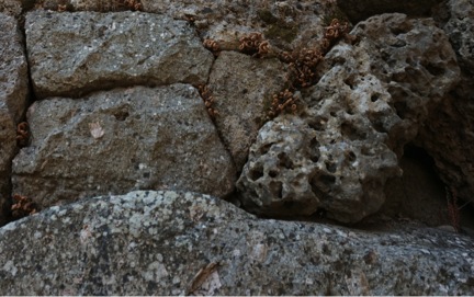
Stones in the Faux-Mycenaean Niche, including Vuggy Crystalline Limestone and Porphyritic Quartz Trachyte. Photograph by J. Mundy
In 2013 Sara Chang, with the assistance of Dr. Bill Size from Emory University, mapped the different types of stone used in most of the buildings around the sanctuary. She created thirteen maps of various buildings around the sanctuary, and in 2014 Rao Lu cleaned and color-coded the maps for future reference.
This year geologist Dr. Bill Size from Emory University has been verifying the stone maps. He has also been standardizing the scientific language used to describe the stones and regulating the identification of the stones from all of the major ancient architectural structures in the sanctuary. Additionally, with Dr. Size’s assistance and expertise, I have been creating new stone maps for areas around the Lower Stoa. The Lower Stoa complex of dining rooms A-P was the only architectural area not previously catalogued.
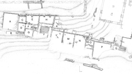
Lower Stoa drawing 9F of the entire Lower Stoa Plan by J. Kurtich 1980
In order to create the new stone maps of this area, I had to work from an actual state plan to keep track of the complicated layers, walls, and structures made of rocks and stones. I first consulted the scanned architectural drawings of the site, and then printed copies of the actual state drawings of the Lower Stoa.
For the past two and half years, I have been working with the Samothrace project to help sort and organize the database of Samothrace records and have worked closely with the digital copies of the architectural drawings of the site. For this stone mapping project I went through our records and printed copies of the 1994 actual state drawing of the south portion of the Lower Stoa by John Kurtich, as well as three other drawings for other parts of the Lower Stoa.
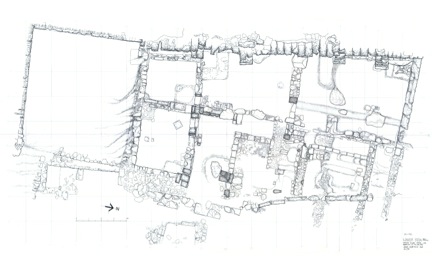
Actual State plan of the south Lower Stoa, drawing 9D, from 1994 by J. Kurtich
After I had prepared the plans, I consulted with Dr. Size on types of stones. Dr. Size taught me how to identify the different types of stones that were used in the structures around the Lower Stoa. Then I spent time in the field closely inspecting each stone, and identifying the types on the actual state plan for four different sections of the Lower Stoa. Finally, I checked back with Dr. Size for corrections to my determinations for accuracy.
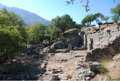
Lower Stoa, viewed from north. Photograph by Dr. Bonna Wescoat 2009
The stone maps are now being digitized for future research, using a combination of Adobe Illustrator and ArcGIS software. Once finished we will be able to use these plans as a resource for future studies on the construction sequence of the buildings, the sources of stone for the sanctuary, and various other future studies.
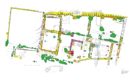
Working stone map of the south Lower Stoa, plan by J. Kurtich, 1994, stone mapping by Dr. Size and J. Mundy, 2015